US 85 Upcoming Construction Information
Project Status: Construction Underway
Regarding the widening and reconstruction on US Highway 85 between Highlands Ranch Parkway and Dad Clark Gulch (that is located approximately 1,200-feet north of County Line Road), bids were opened on July 28, 2022, and the Douglas County Commissioners awarded a construction contract on September 20, 2022.
The selected contractor was given a Notice to Proceed on September 30, 2022, and the contractor selected is allowed up to 36 months to complete the project. Construction began October 3, 2022. As of November 1, 2024, the construction is approximately 90 percent complete.
This project site will continue to be used to provide the public with project information developed prior to construction (pre-construction activities), and below is a link to project construction information.
For current construction information, visit https://www.douglas.co.us/us-85-construction
Email Project Construction Questions to US85improvements@gmail.com
Work-in-progress construction plans as of April 26, 2021
Work-in-progress construction plans for Highlands Ranch Parkway to Dad Clark Gulch:
- General Plans
- Removal Plans
- Roadway Plans
- Bridge Plans
- Wall Plans (South)
- Wall Plans (North)
- Bikeway Plans
- Grading Plans
- SMWP Plans
- Drainage Plans
- Pothole Plans
- Utility Plans
- ITS Plans
- Waterline Plans
- Lighting Plans
- S&S Plans
- Phasing Plans
- Signal Plans
Project Description
CDOT and the County are widening and reconstructing approximately 2.5 miles of US 85. The project limits are from Highlands Ranch Parkway to Dad Clark Gulch (about ¼ mile north of County Line Road), and it is estimated to take 30 months to construct. The improvements to be constructed include:
- a six-through-lane section (eight lanes including the auxiliary lanes)
- continuous flow intersections at Town Center Drive and Highlands Ranch Parkway
- a raised median, inside curb and gutter, outside curb and gutter, inside shoulders, and continuous auxiliary lanes
- bus stop enhancements
- a shared-use path for bicycles and pedestrians on the east side of the road
- improvements to the High Line Canal Trail by changing the existing at-grade crossing to a grade-separated crossing under US 85
- access consolidation includes modification to right-in/right-out accesses
The portion of the project that extends north of Blakeland Drive includes replacing and widening the bridge that carries US 85 over C-470. It also provides a new grade-separated trail connection for the C-470 Trail that will carry the Centennial Trail under US 85 along the south side of C470. This allows bicyclists and pedestrians the option to cross under Santa Fe Drive, (US 85), without being interrupted by the heavy traffic on US 85 and the C-470 eastbound off-ramp. The proposed new and wider US 85 bridge over C-470 will provide a much-needed pedestrian and bicycle connection between the C-470 Centennial Trail and the Wolhurst Senior Community – which is located west of the US 85 / County Line Road intersection and presently has no pedestrian access.
Additionally, replacing the bridge over C-470 enables the project to upgrade to a new CFI interchange configuration (Sheet 4) similar to the ones designed for Highlands Ranch Parkway (Sheet 1) and Town Center Drive (sheet 2).
Watch a video of a Continuous Flow Intersection (CFI) in action.
Download the map and sheets 1-5 in one package or, select a sheet on the map below to download that specific section.

Project Funding
The total project is estimated to cost more than $100 million. The project was selected to receive approximately $26.2 million federal funding via the Denver Regional Council of Governments (DRCOG) through the Transportation Improvement Program (TIP) project selection process. Additionally, CDOT will be contributing $7.6 million while the reminder of the project costs is Douglas County’s responsibility (approximately $68 million needs to be allocated for environmental clearances, preliminary and final design, right-of-way acquisition, utility relocations and for construction and construction engineering services). A portion of Douglas County’s contribution is funded by developers in the Chatfield Basin, which increases as development occurs.
Project Background
For many years Douglas County and the Colorado Department of Transportation (CDOT) have been making improvements to the US 85 Corridor based on the 2002 South I-25/US 85 Environmental Impact Statement (EIS) and Revised Record of Decision (ROD). As additional residential and commercial growth occurs in the northwest portion of the county, further studies were needed to identify what transportation improvements are necessary to support the development. Douglas County secured additional funds to continue this work and sponsored two important studies of US 85. The two separate studies are closely coordinated at each step in the process to allow citizen and stakeholder input. Ideally, these efforts assist the County and other agencies in identifying issues of importance in order to implement the highest-priority near-term improvements as soon as possible.
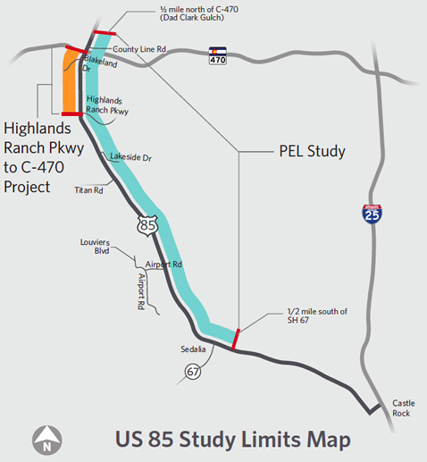
- The PEL Study recommends improvements from approximately State Highway 67 (SH 67) in Sedalia to ½ mile north of C-470.
- The Highlands Ranch Parkway to C-470 Project updates the 2002 ROD to reanalyze impacts and began design of recommended improvements for US 85 from Highlands Ranch Parkway to C-470.
- The Highlands Ranch Parkway to Colorado Highway 470 (C-470) Re-evaluation was completed in July 2017 as an update to the 2002 Record of Decision (ROD) to address changes to conditions that have occurred since it was issued by the Federal Highway Administration (FHWA). The Reevaluation identifies changed existing and future conditions; identifies a refined Selected Alternative for improvements to improve capacity, operational performance and safety for traffic volumes in 2040; identifies changes in legislation, regulations, and guidance related to the improvements; reanalyzes impacts; and develops needed changes to the mitigation measures identified in the FEIS/ROD. You can review the final Re-evaluation document here.
- The Planning and Environmental Linkages Study is complete. Review the final report.
- Visit the PEL Study section to see a brief recap of the findings in the PEL report.


